Aircraft Tracking via Satellite
Global tracking and communication solutions to keep your aircraft connected and secure.

Key Features of our Aircraft Tracking & Monitoring System
Global, Real-Time
Tracking
Track and manage your aircraft anywhere on Earth with precision and reliability. Our satellite-enabled, aviation-compliant tracking devices ensure your fleet is visible and secure, no matter how remote the location.
Uninterrupted Connectivity
Stay connected with your team wherever they are flying. Our devices offer reliable communication through satellite and cellular networks, enabling critical updates, coordination, and safety assurance in the most challenging environments.
Streamlined Fleet Management
Cloudloop provides complete fleet visibility, message history, and group communication. Pilots can use the companion app for two-way messaging, while operators can monitor and manage correspondence in real time.
Safety and Compliance First
Built to meet aviation standards, our tracking devices prioritize reliability and safety. With features like emergency alerts, geofencing, and detailed trip recording, you can maintain compliance and protect your pilots and aircraft.
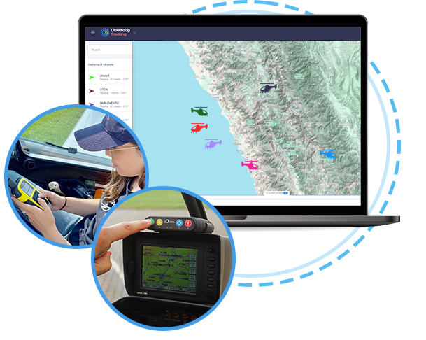
Track your Pilots and Fleet with Cloudloop Tracking
![]()
Global Aircraft Visibility
Track your aircraft anywhere in the world with reliable, satellite-enabled connectivity.
- Seamlessly integrates with devices like the RockAIR for real-time location tracking
- Provides 24/7 global coverage, including remote and oceanic areas
- Ensures your fleet is always monitored, enhancing operational oversight
- Ideal for managing individual aircraft or entire fleets.
Comprehensive Flight Data
Monitor key flight metrics to gain valuable insights into aircraft performance.
- Track speed, altitude, and overall flight behavior in real time
- Record take-offs, landings, and signal loss for complete flight oversight
- Identify and address performance trends or anomalies promptly
- Ensure compliance and improve operational decision-making.
Instant Alerts for Safety
Receive immediate notifications of critical events to protect your crew and assets.
- Alert button activation triggers instant notifications to ground operators
- Geofence entry/exit alerts help track aircraft movement in restricted zones
- Provides actionable insights during emergencies or unexpected incidents
- Promotes faster response times to enhance safety and accountability.
Historical Reporting Made Simple
Review past flight data to optimize operations and meet compliance requirements.
- Access detailed historical position reports for each flight
- Analyze trends to improve future planning and route efficiency
- Retain records for training, legal, or audit purposes
- Share historical data with stakeholders for transparency.
Map-Based, User-Friendly Interface
Easily visualize and manage your fleet through an intuitive map-based dashboard.
- View real-time positions and historical routes in a single platform
- Simplify decision-making with a clean, easy-to-navigate interface
- Monitor multiple aircraft simultaneously with clear, organized data
- Customize views to focus on the details that matter most to you.
Tailored for Aviation Needs
Designed with simplicity and reliability for aircraft owners and operators.
- Perfect for flight schools, scenic tour operators, and small private fleets
- Offers essential tracking and communication tools without unnecessary complexity
- Scales easily to meet the needs of diverse aviation operations
- Backed by Ground Control’s expertise in satellite-enabled connectivity.
Who Uses Ground Control's Aircraft Tracking Solutions?

Agricultural Aircraft
When crop dusting or topdressing, accurately tracking distance is crucial for billing. A satellite-enabled tracker is essential in areas without cellular coverage, offering hyper-accurate GPS readings, global coverage, and live and historical tracking data on an intuitive dashboard. Includes emergency alerts and two-way communication.

Flying Schools
A satellite-enabled tracking and communication device onboard your trainer aircraft greatly enhances pilot safety. It provides real-time global tracking, historical data on position, speed, and altitude, an emergency button for faster tracking and alerts, two-way messaging via Bluetooth, and cost-efficient hybrid cellular/satellite connectivity.

Airplane and Helicopter Tours
Enhance pilot and passenger safety with a global tracking and monitoring solution. It offers real-time location tracking, historical data for improved flights, an emergency button for faster tracking and alerts, take-off and landing notifications, geofencing with alerts, and cost-saving cellular connectivity where possible.

Charter Flights
Whether servicing private jets, group charters, cargo, or helicopters, knowing the location of your aircraft, pilots, and passengers enhances safety and communication. Our carry-on/carry-off device, typically mounted on the glareshield, provides 100% global tracking using the Iridium satellite constellation.
Private Aircraft Owners
Give your family, friends, and colleagues peace of mind with a satellite-enabled tracking and communication device for your flights. It offers global coverage, real-time and historical tracking on a map-based interface, easy carry-on/carry-off use, two-way messaging, and an emergency alert feature to notify chosen contacts quickly.

Search & Rescue
Staying connected is crucial for safety and coordination. Ground Control’s satellite-enabled tracker provides two-way communication along with real-time tracking and monitoring. It offers global coverage, features a map-based interface with current and historical locations, and includes emergency alert features.
How Does Our Aircraft Tracking Work?
The tracker’s integrated sensors capture the location, speed, altitude, heading and temperature of your aircraft, plus power loss and impact
Embedded aircraft sensors record fuel levels, weight, wear and tear, payload status and other telemetry, which is passed via serial or digital input to the tracker
All data captured by the tracker is passed on, by satellite or cellular*, to Cloudloop Tracking, or your preferred platform in real-time, so you can act on the information
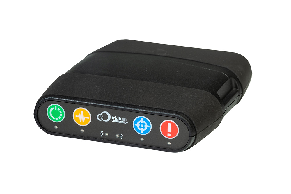
*Cellular capabilities are dependent on the tracker. RockAIR has dual mode cellular and satellite connectivity, RockSTAR does not.
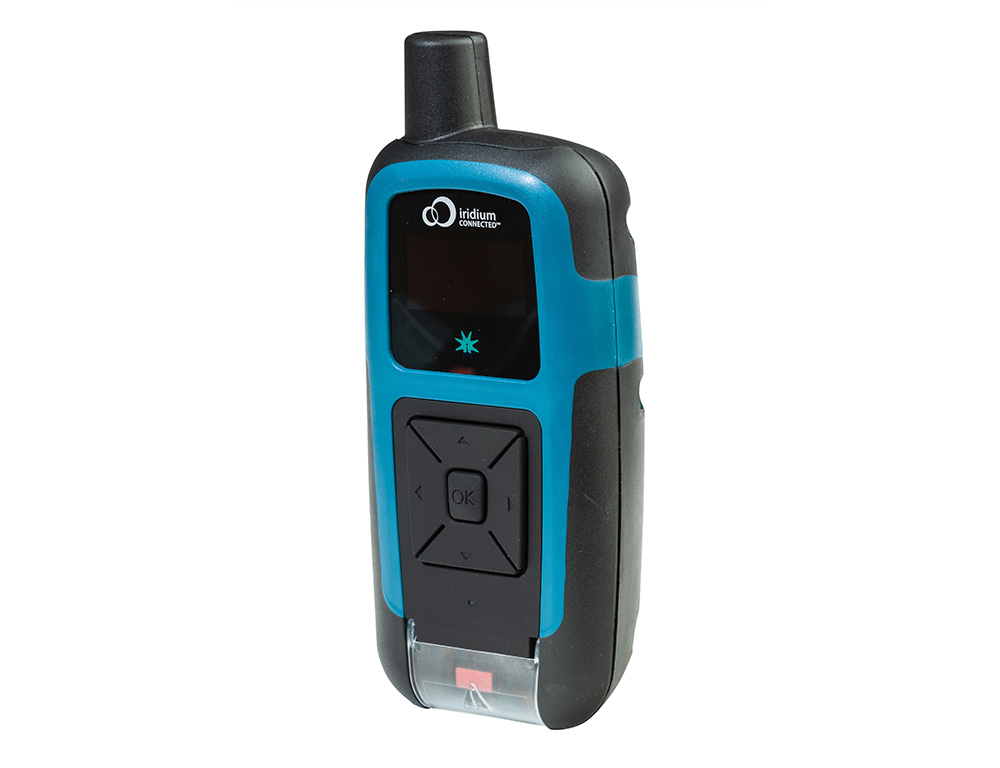
Recommended Devices for Aviation Tracking
RockSTAR is battery powered, and will last up to 12 months on a single charge. It's the preferred device of aviators who want a simple, robust safety solution, and a means of staying connected with their team or family. This device helped save the life of a co-pilot flying a Piper PA-46-350p, enabling him to text his wife when he crash-landed in Canada.
Aviation Tracking Partners
If you need more sophisticated tracking functionality, please visit our aviation partners.
IndigoSat provides aircraft tracking across Europe, the Middle East, and Africa with RockAIR hardware and the MiTrac platform. RockAIR ensures seamless communication via cellular and Iridium satellites, while MiTrac delivers real-time tracking, dynamic reporting, and comprehensive operational insights.
TracPlus, a leader in aerial firefighting solutions, utilizes the RockAIR device to provide seamless global tracking and communication. This collaboration enhances operational intelligence and safety, enabling streamlined decision-making through real-time data and a unified platform.
v2track’s advanced platform offers global asset tracking, fleet management, real-time monitoring, and two-way communication. Paired with dual-mode RockAIR, RockFLEET, and RockSTAR devices, it delivers a cost-effective, end-to-end solution for tracking across air, land, and sea.
Serving sectors including emergency medical services, business aviation, and military and government operations, SKYTRAC’s offerings are designed to enhance safety, efficiency, and connectivity for both manned and unmanned aircraft. Capabilities include HUMS alerting, and C4ISR video.
Packages Tailored to Suit Your Needs
Platform Only
If you have already purchased a aircraft tracking device, and would like to integrate it with Cloudloop Tracking, come and talk to us. We offer support for many Iridium, Viasat and Globalstar-enabled trackers.
Our Data, Your Platform
Our well documented, robust APIs allow you to integrate the data transmitted via our devices to the platform of your choice. We have many existing integrations, and make it easy to feed your application.
Device, Data and Platform
Our integrated solution delivers everything you need to monitor your aircraft. Our best-in-class hardware delivers your tracking and telemetry data in close to real-time to our intuitive and feature-rich platform.
Device Only
You are welcome to purchase just the aircraft tracking devices you need from us, organizing your own airtime contracts, and integrating the data with your preferred platform.

Can we help?
We have over 20 years’ experience delivering satellite-enabled asset tracking solutions to aviators worldwide.
We’re proud to design and build our own hardware, and we work with other leading manufacturers and airtime providers to ensure that all of our customers get the best solution for their needs.
Complete the form or email hello@groundcontrol.com, and we’ll respond with impartial, expert advice.